

Tallulah Gorge
- otomola
- Mar 29
- 5 min read

March 26-28, 2025
I arrived at Tallulah Gorge State Park on Wednesday, March 26. It was a rather short drive from Amicalola Falls. The road was mostly through narrow valleys between tree covered mountains. There were a few climbs up and the terrain that had a very curvy layout. Those parts were slow going. Google wanted to send me on some road that I think would have been like that, hills and curves, and might have saved a little time, but I opted for Route 115, which was the main road on my map. It turned out this road ran between the hills. The last several miles were on Route 441, a four lane road with a narrow shoulder. All along the route, I was evaluating the road for bicycling, and there was little good news on that account. Once again there were narrow shoulders and rumble strips along the asphalt edges. I was disappointed, and by the time I reached Tallulah Falls, it looked like it would not be a good place to ride.
Instead, I just figured I’d do more hiking here. The main reason I came here was to see the gorge and hike down into it. It was touted as the Grand Canyon of Georgia, and I wanted to see what it was like. I’ll start by saying Canyonlands in Utah, with its sweeping views, would remind someone of Grand Canyon. Tallulah Gorge did not have that sensation. Part of the reason is it is densely populated with trees, both along the rim and down the sides of much of it. One cannot see from the rim into the canyon in many places due to the trees. But there are some wonderful spots that impress one’s spirit. Another significant difference is its short length of two miles.
That said, I went to the visitor center at 8AM on Thursday to obtain my permit to hike the trail in the gorge. A park ranger gave a twenty-minute orientation for the hike, talking about safety and dangers within the gorge. I’ll note that on Wednesday afternoon, yesterday, there was a helicopter rescue. Someone had slipped on a rock and broken their arm. Hiking out would have been impossible for this person, so I was told.

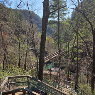
The Tallulah River runs from Tallulah Lake, passing along those two miles in dramatic fashion before exiting. The canyon walls range from about 400 feet at the lake end to about 1000 feet at other places downstream. There are five main sets of waterfalls. There are two routes to drop down to the river. Hikers are told to descend by way of the North Rim and return up to the South Rim. Amazingly, there is a staircase that leads down to the bottom from the north side. The staircase is similar in construction to those at Amicalola Falls, mostly wood but with metal grids making the actual steps. There is a long suspension bridge that crosses the river after one descends about 300 steps. It sways as you walk over it, providing an eerie yet interesting feeling. After the bridge, there’s another 200 steps down. These steps are not in a long straight line for the most part. The path they make twists and turns frequently due to the steepness and rugged terrain.

After negotiating the 500+ steps one finds oneself at the river. A permit is not needed to reach this part of the hike. The permit is required to go farther, to enter into the gorge and hike downstream. This was explained in the orientation meeting.
One of the first warnings was that if you are going to do this hike, you are going to get wet. The challenge at this point is the first of two crossings of the river. The ranger had said, unless you were very good at jumping rocks, you would have to take your boots off here and walk through the stream. It looked sketchy. The rocks in question were fairly large boulders that rose out of the water in irregular shapes. They were not flat. I visualized I would have to use a “three point” manner of passing, that is use both legs and one hand-arm, to scramble over the boulders. But there was one point where it looked like there was quite a gap between boulders. I was not sure it could be jumped.

After the crossing, the trail heads downstream. Well, the ranger said it’s not really a marked trail. It is rocks and roots, which may be wet, and one has to evaluate and make one’s path as one goes. There is a lot of scrambling, she said, as she pointed out on a map and in photos some tricky sections, noting where the person with the broken arm fell the day before. When one reaches the “end” of the trail, the second river crossing needs to be done. This time, there are no rocks rising out of the water to utilize. One has to take off boots again. The ranger explained the rocks are relatively flat here, but they have algae on them, and rather than taking steps she recommended to carefully slide one’s feet across the rocky surface.
After the crossing, the final challenge is a scramble up the South Rim. Again, she said there’s no marked trail. There is a semblance of a trail and one must bushwack up a narrow field of rocks and boulders, climbing 800 feet over a quarter of a mile.
It just so happened that, at the time I reached the bottom, there was a guy that was just beginning to cross the river. I observed from a distance of about fifty feet. It was slow going as he evaluated his path and moved rock to rock. Indeed, he did have to crawl or scramble from rock to rock, as compared to walking and hopping. Then he came to the gap. There was swift running water coming through the gap, white-water, and I have no idea how deep it was. He apparently decided not to jump it and not to wade through it. Instead, he opted for a wider section of tranquil water that preceded the gap. He took off his boots and waded into the water. I was surprised to see, as was he perhaps, that the water reached well over his waist, partway up his torso, before he could climb up onto the other side. His backpack got a little wet as did his t-shirt halfway up his body. He took it off and wrung it out.

The combination of the ranger’s morning talk and my observations of the hiker convinced me soundly that doing the hike in the gorge was unnecessary, perhaps dangerous and ill-advised. I opted for heading back up the stairs. At the suspension bridge, I took a left turn and hiked up the 350 steps to the south rim, rather than return the way I had come down from the North Rim.
There are ten marked viewpoints along the rim. They are quite beautiful and moving, but it’s not like Grand Canyon, even when there are no trees blocking the view.


Later in the day, I went for a bike ride. I learned there is an old road (Old 441) that parallels the main road (New 441), and together they formed a three-mile loop I could ride. It turned out I was able to get a ride in every day here with very little traffic.
Two tidbits of information. Tightrope walker Karl Wallenda walked across the gorge (1970) and parts of the movie Deliverance (1972) were filmed here.


Comments