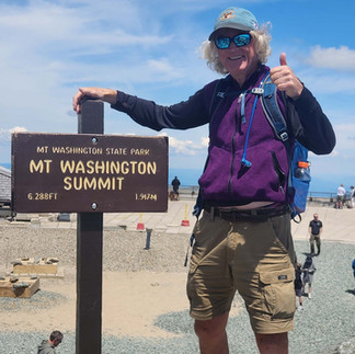
Tuesday, July 2, 2024
I woke early, had my cereal, and drove to Pinkham Notch. I had eggs and home fries when I arrived there, then I went in at 6:30, when the visitor center opens, and checked the weather to confirm what I thought: it was going to be a mostly sunny day with moderate temperatures and light winds. I began hiking at 6:45. The sign says it is 4.1 miles to the top via Tuckerman or Lion’s Head trails. The trail starts out on dirt, but the “dirt only” section is short lived. In rather swift time, it becomes more and more rocky. There are a variety of boulders all the way to the top of the mountain.
In my mind there are four main sections of Tuckerman. The first section runs 2.4 miles from Pinkham to the Hermit Lake Shelters. It gains 1800’ in this section. Some parts have small (1-2’) boulders, other sections have bigger rocks. There are a few places where runoff is guided across the trail by the placement of boulders, done by trail crews. There are a few stream crossings facilitated by bridges, too. The second section is about 0.7 miles and leads to the base of the ravine. One obtains fantastic views of the Tuckerman’s Ravine along this section, including several dramatic waterfalls. Boulders have been placed strategically in some places here such that they appear to be steps, some of them being rather large steps. Once on the ravine, the trail seems to become steeper yet, climbing another 0.7 miles to the top of the ravine. There were many areas here with wet rocks, several places where one had to cross the small streams that feed the waterfalls. There are some sections were one has to make use of hands as well as feet, helping to pull oneself up the rocks. The final section seems to be a “trail” in name only. It is marked by frequent large-sized, rock cairns. My first thought, when seeing this section, was “Oh no. You got to be kidding me!” It is a scramble across a steep boulder field. One fortunate reality is that the boulders were solidly in place. There was only one step where, when I put my foot down, a boulder rocked some. But one has to pick one’s way up the steep slope rock by rock. There isn’t any sense of being on the right or wrong path. It took me about half an hour to negotiate the last three-tenths of a mile. It took me 3h 20m to reach the top. Pinkham Notch is at 2028’ and the peak is 6288’.
When I was on the lower part of the ravine trail, I caught up with a group of kids being led by camp counselors. I learned from one of the counselors that the camp is a program for kids 8-16. They do outdoor things, including hikes and camping, and this was a hike for kids 12 and older. They seemed to be handling it just fine. I was surprised to see some kids in sneakers. One boy told me the hike they did previous to this was harder.
I surprised myself at the top. I decided to take the shuttle down. The main reason for this was I felt it was safer, and the smarter thing to do. The boulder field and the wet rocks on the ravine made me feel uneasy, and both my logical mind and gut feeling told me this was the better choice today. I imagined it would take me longer to descend than it took to ascend, too, and I did not want to get back to my van with my legs beat up, late in the day, and then have to do my three-hour drive to Mount Ascutney State Park, where I was staying that night.


Comentários